1. Home
  2. France
  3. Hauts-de-France
  4. Zuydcoote
Zuydcoote

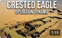
Epave du Crested Eagle Opération Dynamo - Zuydcoote

Coordinates51.07584, 2.49117
Published bySebdrone62
01 Sep 2026 · 09:25 AM
Community score
0

Log in to vote

Categories
🌊 Plan d'eau
Aviation weather· 04
Flight footage· 05
Comments· 06

No comments yet. Be the first!

Log in to comment

Nearby spots· 07
  • zuydcoote hauteur max 50mZuydcoote< 1 km
  • Plage de Bray-DunesBray-Dunes2.8 km
  • Parc d'agglomération du Fort Louis - Coudekerque BrancheCoudekerque-Branche10.6 km
  • Zone du barochGrande-Synthe14 km
  • Parc du moulinGrande-Synthe14.5 km
  • ATHENA au fil de l'eau - BrouckerqueBrouckerque22 km
  • ATHENA au fil de l'eau - BrouckerqueBrouckerque22 km
  • Le Lac Bleu - WattenWatten33.3 km
Live wind· 08
Windy
Epave du Crested Eagle Opération Dynamo - Zuydcoote
Pilot briefing
Difficulty
1/3
Beginner
Accessibility
1/3
Easy to access
Description

-Sur la plage de Zuydcoote, c’est une page de l’histoire de la Seconde Guerre mondiale qui se dessine avec l'épave du Crested Eagle, bateau à vapeur anglais qui participa à l’Opération Dynamo.
Restrictions here· 03
2 active rules
  • [LF-EB][CTR KOKSIJDE]Aerodrome · ≤ 50 m
  • [LF][PRN 017] DUNE MARCHANDAerodrome / other · No-fly
Wed, Nov 11
2:11 AM
Conditions
Sunrise
Sunset
Precipitations
Temperature
KP index
Cloud cover
Wind speed
Wind gust
Visibility
Humidity
Satellites
DroneSpot Pro

Plan your flights in advance and find your windows with access to detailed 10-day forecasts showing conditions, satellites, wind, kp index, and more.