1. Home
  2. France
  3. Corse
  4. Ajaccio
Ajaccio

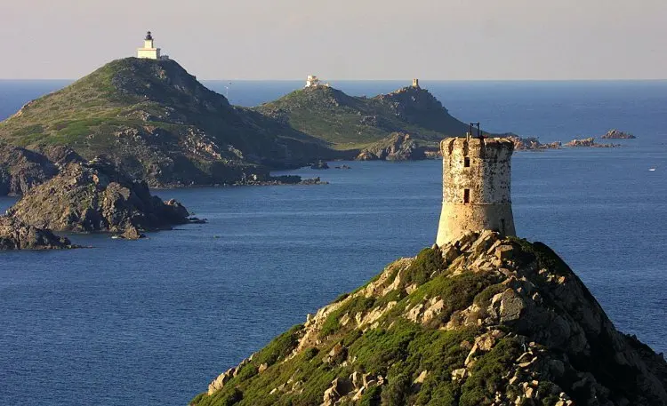
Iles Sanguinaires

Coordinates41.89492, 8.60843
Published bymoyssick
20 May 2018 · 12:00 AM
Community score
0

Log in to vote

Aviation weather· 04
Comments· 05

No comments yet. Be the first!

Log in to comment

Nearby spots· 06
  • St AntoineAjaccio7.2 km
  • Tour de capu di muruCoti-Chiavari17.1 km
  • Pont du LiamoneCasaglione22.3 km
  • Lac de TollaTolla31.4 km
  • Phare de SenetosaFozzano36.8 km
  • Forêt ZerubiaZérubia38.1 km
  • Capo RossoPiana38.2 km
  • Plage de ficarolaPiana39.7 km
Live wind· 07
Windy
Iles Sanguinaires
Pilot briefing
Difficulty
3/3
Hard Level
Accessibility
1/3
Easy to access
Description

Magnifique endroits ! Les îles sanguinaires , attention au survol de personne l'été
Can I fly here?· 03

50 m maximum

You can fly up to 50 m above the ground.

Max height : 50 m

  • [LF][CTR AJACCIO]Conditional

    The zone starts 50 m above the ground: stay below it.

  • Height limited to 50 mConditional

    The DGAC restrictions map limits flight height to 50 m.

  • Iles Sanguinaires, plage de Lava et Punta PellusellaNo known restriction

    Protected area with no known overflight ban. Respect wildlife and plants.

A local order (prefecture, town hall) may also restrict flying. Stay alert on site.

Computed on November 15 at 12:55 AM

See on the map
Sat, Nov 14
11:55 PM
Conditions
Sunrise
Sunset
Precipitations
Temperature
KP index
Cloud cover
Wind speed
Wind gust
Visibility
Humidity
Satellites
DroneSpot Pro

Plan your flights in advance and find your windows with access to detailed 10-day forecasts showing conditions, satellites, wind, kp index, and more.